Aerial view of Aquinas University of Legazpi
Showing posts with label Aerial Photography. Show all posts
Showing posts with label Aerial Photography. Show all posts
Thursday, August 23, 2012
Monday, July 30, 2012
Sunday, July 29, 2012
Aerial view of San Pedro, Laguna
Saturday, July 28, 2012
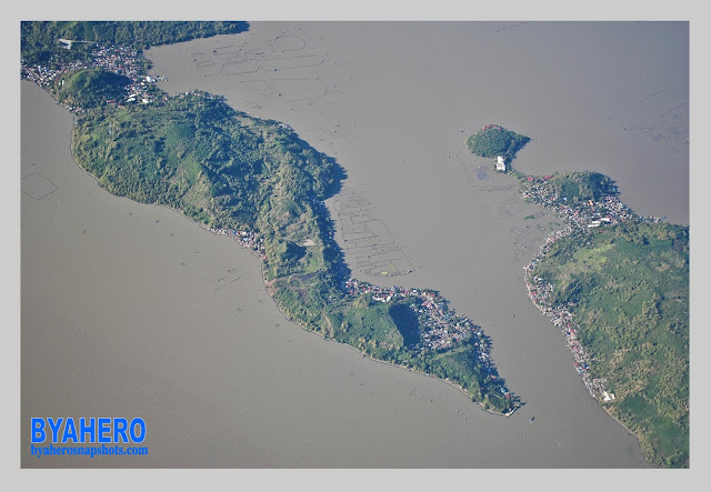
Aerial view of Talim Island in Laguna de Bay
Monday, July 2, 2012
Saturday, June 30, 2012
Saturday, June 16, 2012
Saturday, March 24, 2012
Snapshot | The Manila-Cavite Expressway
Snapshot | The Manila-Cavite Expressway or Aguinaldo Boulevard. It is also nicknamed the Coastal Road because of its vicinity to the Manila Bay.
Tuesday, March 20, 2012
Saturday, March 17, 2012
Aerial view of Camalig, Albay
Magayon Festival 2012
April 10 - May 10
Legazpi City, Albay
--------------
Friday, March 16, 2012
Aerial view of Daraga, Albay
Magayon Festival 2012
April 10 - May 10
Legazpi City, Albay
--------------
Wednesday, February 29, 2012
Tuesday, February 7, 2012
Wednesday, November 2, 2011
Saturday, September 10, 2011
Saturday, July 23, 2011
Aerial View of Mt. Mayon
Aerial view of Mount Mayon
Mayon Volcano, also known as Mount Mayon, is the Philippines’ most active volcano and is considered to be the world’s most perfectly formed volcano because of its symmetrical cone.
Sunday, January 2, 2011
Sunday, September 12, 2010
Subscribe to:
Posts (Atom)
Popular Posts
-
Festivals in Camarines Norte • Pinyasan Festival – Camarines Norte • Rahugan Festival - Basud • Palong Festival - Capalonga • Bant...
-
Pottery is a century old industry of Tiwi in Albay. It provides with world-class decorative ceramics made of terra cotta and the re...
-
Tribu Himag-Ulaw Festival of Placer, Masbate emerged as champion in the 2014 Gayon Bicol: Festival of Festivals Showdown sa Daragang Ma...
-
The St. Stephen Proto-martyr Church is a place of interest in Ligao City , a sight worth seeing. St. Stephen Proto-martyr Churc...
-
Antipolo's Maytime Festival 2014 Sumakah Festival Street Dancing Competition May 1, 2014 | Antipolo City , Rizal
-
Rizal Monument in San Juan City This coming sunday, June 19 is the sesquicentennial or 150th birth anniversary of the country’s nation...
-
PHILIPPINE FESTIVALS AND EVENTS JANUARY 2016 January 1 | NEW YEAR’S DAY (Holiday) January 1 | AGUMAN SANDUK | Minalin, Pa...
-
Ligao City's Christmas Main Street Parade 2012 | Tangled Links: Ligao City's Christmas Main Street Parade 2012 Contingent # 1 | Tan...
-
Angono is a 1st class urban municipality in the province of Rizal. Angono came from the word "ang nuno" meaning an old man on the ...
-
Featured Photos | Busaingan Festival 2012 | Sta. Magdalena, Sorsogon Photos by John Lester Rico | JLER iShoot
Popular Posts
-
Festivals in Camarines Norte • Pinyasan Festival – Camarines Norte • Rahugan Festival - Basud • Palong Festival - Capalonga • Bant...
-
Rizal Monument in San Juan City This coming sunday, June 19 is the sesquicentennial or 150th birth anniversary of the country’s nation...
-
Urdaneta City is a 1st class city in the province of Pangasinan, Philippines. Urdaneta City Hall History There are many versions on how Urda...
-
Pottery is a century old industry of Tiwi in Albay. It provides with world-class decorative ceramics made of terra cotta and the re...
-
Legazpi Boulevard is a coastal road and seawall project in Legazpi City. It is more than four kilometer seaside road with a panoram...
-
CALENDAR OF FESTIVITIES JANUARY January 1 | NEW YEAR’S DAY (Holiday) January 1 | AGUMAN SANDUK | Minalin, Pampanga Januar...
-
Featured Photos Ibalong Festival 2012 Epic Street Presentation Contingent # 11 | Philippine Science High School, Goa, Camarines Sur Photo...
-
PHILIPPINE FESTIVALS AND EVENTS JANUARY 2016 January 1 | NEW YEAR’S DAY (Holiday) January 1 | AGUMAN SANDUK | Minalin, Pa...
Popular Posts
-
Festivals in Camarines Norte • Pinyasan Festival – Camarines Norte • Rahugan Festival - Basud • Palong Festival - Capalonga • Bant...
-
St. Luke's Medical Center is a tertiary referral hospital located in Bonifacio Global City, Taguig City. It is the most advanced ho...
-
CALENDAR OF FESTIVITIES JANUARY January 1 | NEW YEAR’S DAY (Holiday) January 1 | AGUMAN SANDUK | Minalin, Pampanga Januar...
-
Green Park Resort, Atimonan Quezon RESORTS & HOTELS IN ATIMONAN, QUEZON PROVINCE De Gracia Beach Resort Brgy. Balubad 0923‐7...
-
PHILIPPINE FESTIVALS AND EVENTS JANUARY 2016 January 1 | NEW YEAR’S DAY (Holiday) January 1 | AGUMAN SANDUK | Minalin, Pa...
-
OAK PARK HOTEL & RESIDENCES Padillo Building, Enriquez cor. Hermana Fausta Sts., 4301 Lucena City Phone: (042) 373-6764 or 710-6148 DIAM...
-
The Oriental Legazpi Hotels THE ORIENTAL LEGAZPI (First Class) Sto. Nino Village, Taysan, Legazpi City Tel: (+632) 470 9737 | 404 7501 |...


.jpg)


.jpg)

.jpg)


.jpg)
.jpg)
.jpg)

.jpg)


